Back in 2016 we participated in The Fighting Irish Roadshow held in King House, Boyle, Co. Roscommon. As part of the preparation for that talk, we had a preliminary look at some of the archaeological potential offered up by the revolutionary landscape in and around Boyle. Aside from the talk itself we have never had an opportunity to share that initial analysis, and so wanted to take the opportunity to highlight some of it here. We hope in the future that we might be able to make Boyle the subject of a more detailed and concentrated Landscapes of Revolution Project.
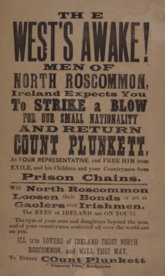
The archaeological landscape of our revolutionary past is not restricted to sites of physical conflict- they can also encompass landscapes of political conflict. Much of this came as a direct result of the 1916 Rising, and can be examined in the surviving buildings of towns such as Boyle, which became a key political battleground. The highly significant North Roscommon by-election of 3 February 1917 saw the return of Count George Noble Plunkett for Sinn Fein. The father of executed leader Joseph Plunkett, his win represented the first parliamentary victory for Sinn Fein and was a sign of things to come in post 1916 Irish politics. Much of the drama surrounding this election was played out in the streets and buildings of Boyle.
The local courthouse was the scene of both the Irish Party’s convention and the count which returned Sinn Fein’s Count Plunkett. In the courthouse on the night prior to the ballots being counted, a guard of police was apparently stationed on one side of the unopened boxes, with a detachment of volunteers staring back at them from the other side.

Other Boyle buildings also played a role in the election: the garage of Pat Delahunty on Bridge Street was where Sinn Fein first began to organise for the election, and they ran their campaign from the Central Hotel and the home of Michael Warde on Green Street, in a building that later became the Princess Hotel. Upon his victory, Count Plunkett was carried from the courthouse on the shoulders of his supporters back to the Central Hotel where he was staying, in the company of individuals such as Arthur Griffith.

The escalation in the political situation manifested itself throughout the town in the months following Count Plunkett’s victory and against the backdrop of the Conscription crisis. One example of this relates to an event at the home of a local British Army recruiter, Major Murphy, at Abbey View in Boyle. He was known for flying the Union Jack from his house (as evident in this National Library of Ireland of the house, below). One night four young Boyle men decided to climb up the building, rip down the flag, and burn in outside Murphy’s front door. Despite efforts to catch the culprits they successfully escaped. One of them was apparently Addie Hayes, who intriguingly later appears to have joined the British Army, where as a member of the Connaught Rangers he participated in the Indian Mutiny. When he and three other local mutineers returned to the locality following their release in 1923, thousands turned out at Boyle train station to meet them.

Many of the buildings in Boyle which witnessed this political activity continued to play a role in the strife to come. These included Delahunty’s Garage, the owner of which became a brigade intelligence officer during the War of Independence, and Warde’s, which became an IRA safehouse.
The War of Independence conflict landscape is something that can be explored from a local perspective. For example we can look at the statement of James Feely, the former O/C of the 1st (Boyle) Battalion of the North Roscommon Brigade, IRA, who describes a number of actions undertaken by he and his comrades during this period. Many of the key sites associated with these events survive. For example in early 1918 Feely and a party of local IRB men raided Rockingham (or Cloontykilla) Castle on Lough Key, tying up the resident butler and taking six rifles, a dozen shotguns and two revolvers from the gun room.

Such raids on large estate homes also happened elsewhere in the area, such as the action of eight volunteers at Woodbrook House near Carrick-on-Shannon, which also secured a number of guns shortly after the Rockingham attack. Moving forward to May 1920, we find Feely and his fellow IRA volunteers launching an operation to seize a fuel consignment bound for the Yorkshire Regiment then stationed in Boyle.
Many of the buildings and locations which were part of this urban guerrilla battlefield survive; the petrol was being stored at the railway station when a party of some 40 volunteers descended to seize it. One group armed with shotguns took control of the railway bridge to control access into and out of the town, while the remainder moved the fuel from the station over the wall across the road and into the grounds of the hospital that once stood there. British patrols failed to recover the fuel during searches, never realising it was being stored right under their noses in the hospital- part of which was being occupied by auxiliary police. This part of the town would again see incidents during the Irish Civil War, when Free State troops under William Dockery were stationed in the nearby Union Workhouse. Dockery, who as a volunteer had escaped from Boyle Barracks during the War of Independence, was shot and killed in the grounds on 1 July 1922.


Boyle Barracks, of which King House formed a part, was also a major centre during the War of Independence. Not only was it a location where British troops provided aid to the civil power, but it was also used as a prison for volunteers. We can briefly demonstrate how we can recreate this conflict landscape using a number of resources readily available to us. Micheál O’Callaghan’s book For Ireland and Freedom: Roscommon’s Contribution to the Fight for Independence, relates the fact that a number of IRA prisoners were being held in the miniature rifle range in the Barracks in 1921. It was described by Andrew Keaveney, who was imprisoned there, as:
a low lean-to shed…it had a door in one end, two windows in the roof and a trench across the clay floor about twelve feet from the door. The windows could not be opened and the door was always locked…it can easily be imagined what life was like in such a confined space during the hot summer of 1921, when the shed held over fifty men.

Although the history of this barracks has been well documented, for demonstrative purposes we can see that a plan of the Barracks in 1919 is available to us online via the Irish Military Archives website. Quickly coupling this type of information with the account provided by O’Callaghan allows us to look at the landscape of one particular incident here.

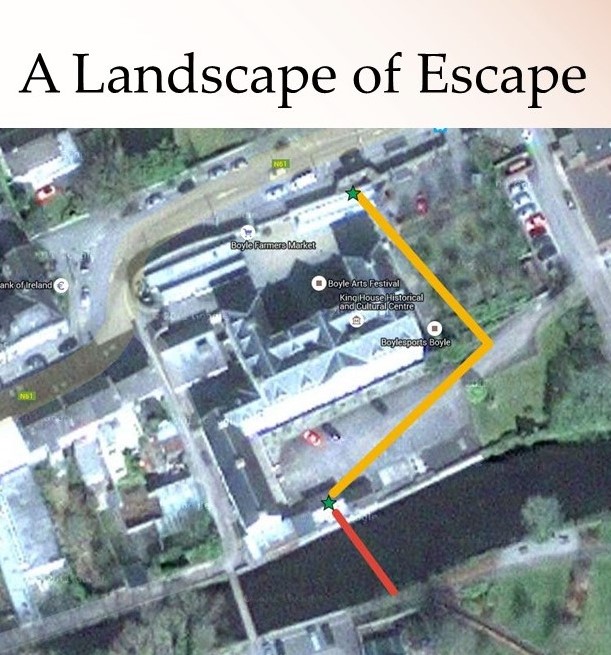
Using messages smuggled out via an altar boy, an escape from the Barracks was planned, the first of two successful efforts from Boyle. Each morning the prisoners were taken in groups from the rifle range and across the barrack square to a washhouse overlooking the Boyle River. A map of a proposed washhouse from the 19th century is also available on the Irish Military Archives site, and is marked on the 1919 map.

At 6.30am on the morning of 21 May 1921, a section of prisoners were taken from their prison to the washhouse, with the guard, as usual, remaining outside while the prisoners washed themselves. The men made sure to make a lot of noise, to distract the guards attention while they hoisted volunteer Jim Molloy out a window and into the river, where he swam across to be met by 6 volunteers who escorted him to safety.
This rough map, which we should stress is for example only, and requires further research and refinement, demonstrates how we might look to “map” such an escape in the modern landscape. It could be continued to follow the full route that Molloy and his accomplices took, which ended at the Roche Safe House near Ballinameen. It is a marker of the high potential of this revolutionary landscape in Roscommon, an area we hope to have the opportunity to explore in more detail as the Landscapes of Revolution Project progresses in the future.