
Recently the images we shared back in 2017 of IRA volunteers in Midleton photographed c. 1922 went viral online. Part of the Dick Cashman/John Fenton Collection, a number of people asked where in the town they were taken. The images were exposed in the Constabulary Barracks, presumably at some point during 1922, as the Civil War loomed. Located behind the Courthouse on Bridewell Lane, the site survives today as part of Midleton Garda Station, with the street now renamed Oliver Plunkett Place. Remarkably, all the elements visible in the photographs still survive, so we took the opportunity to visit and create two “Then & Now” images, demonstrating how much of this revolutionary archaeology still surrounds us.

IRA volunteers at the RIC Barracks (now the Garda Station) likely c. 1922 (Dick Cashman/John Fenton Collection)
The first image shows eight volunteers in and around a motor car facing towards the camera. Among the objects of interest is what appears to be one of the protective metal shields that were used to fortify RIC Barracks during the War of Independence. It leans against the wall at the rear of the vehicle. The photographer in this shot was located near where you would enter the modern Garda station, looking back towards the Courthouse and the Main Street. The same view as it appears today is shown below.
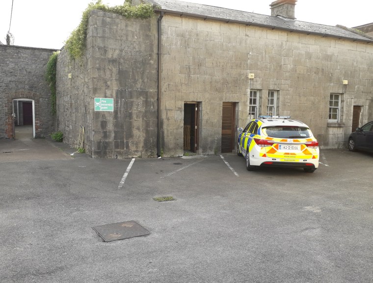
The location where IRA volunteers were photographed with their motor car in Midleton as it appears today (Damian Shiels)
As is apparent from the two images, little has altered in the form or fabric of the buildings since the time of the War of Independence. A side-by-side comparison of the two images confirms this.
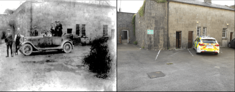
Then & Now comparison of the location where Midleton IRA were photographed at the Constabulary Barracks in 1922
The second image shows two volunteers photographed just inside the gate of the barracks. The image was exposed just to the left of where the motor car photo was taken. Again the photographer was facing towards the Main Street. Among the features visible in the background is the distinctive roofline of what is now Allied Irish Bank. To the left of it is the gable end of No. 1 Main Street, which also occupies part of Oliver Plunkett Place.

IRA volunteers at the RIC Barracks (now the Garda Station) likely during 1922 (Dick Cashman/John Fenton Collection)
It appears clear from this image that the Barracks have been occupied by the IRA. Two benches are present in the courtyard, and a ladder rests against the wall at the rear of the image. The gateway at the left of the image remains the main access point to the complex today.
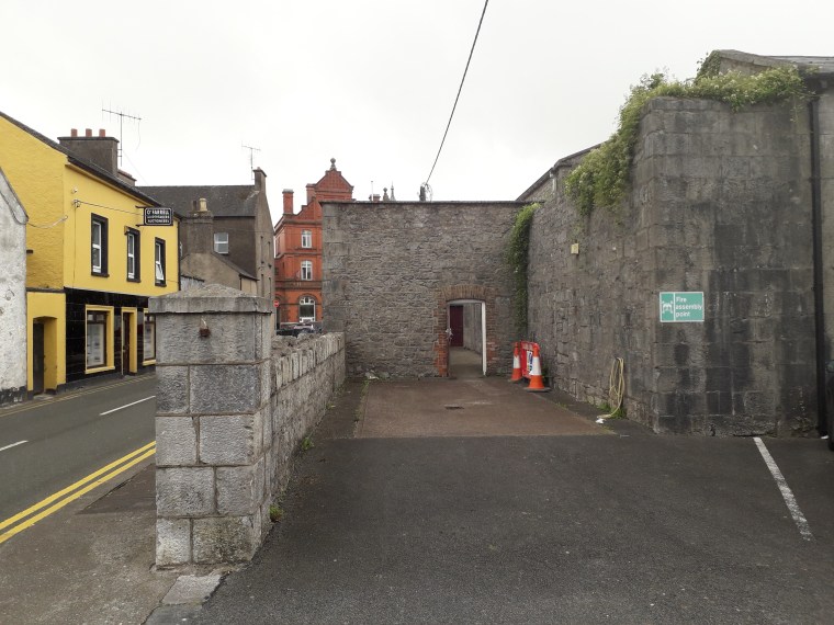
The same view today. The image from 1922 was taken a few metres further back from this location, a perspective which exposed more of the roofline of the AIB Bank. It is clear that much of the streetscape on Oliver Plunkett Place remains as it did during the War of Independence, when this street was the most heavily defended in the town (Damian Shiels)
The side-by-side comparison of the two images is presented below.
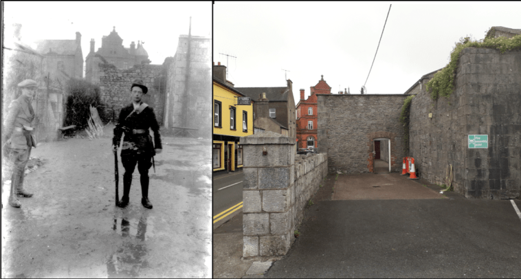
Then & Now comparison of the location where Midleton IRA were photographed at the Constabulary Barracks in 1922
A number of additional details demonstrate some of the changes in the landscape that have taken place. Behind the volunteer’s left shoulder in the second image one of the Bridewell doors is visible–this has since been blocked up (below).
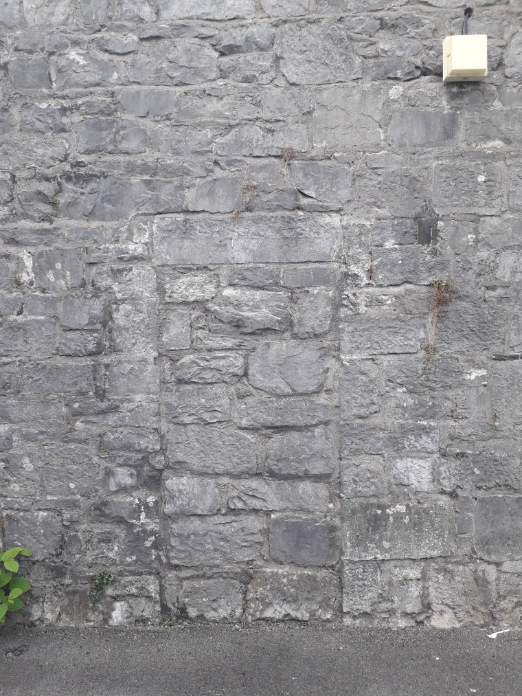
The now blocked-up doorway that is visible in the image of the IRA volunteer (Damian Shiels)
One of the other interesting details is the wall directly behind the volunteer facing the camera, against which the ladder rests. In the 1922 image the top of this wall is damaged–it is unclear if this was as a result of actions at the time or if it had been that way previously. Today the wall has been repaired. However, close inspection reveals that the line of repair is still visible, as indicated by the red arrows in the image below.
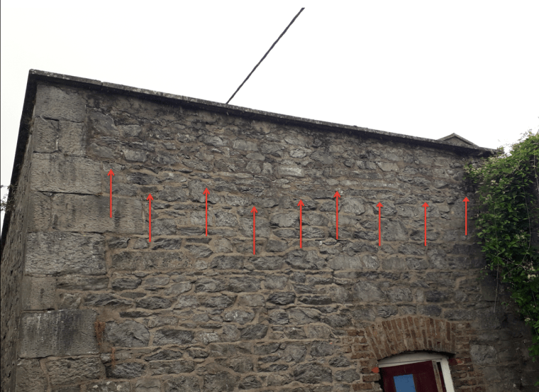
Damage that was present during the IRA occupation of the site visible as a repair line on the modern building (Damian Shiels)
These two striking photos illustrate how contemporary photography can help us to identify elements of the War of Independence and Civil War archaeological landscape that survive–or have been altered– since 1913-23. They also help bring to life the events of the time, allowing us to bridge the decades that separate us from that period by experiencing the same surroundings that these men did almost 100 years ago. Future posts on the site will return to this topic, particularly with respect to the work we have carried out on the 1920 Midleton Ambush.
*Many thanks again to John Fenton for bringing these images to our attention and allowing us to share them.
