
We are excited to announce that our next public event will be held in Cahir on Thursday, the 23rd of June. This will be a Research Evening where historian Niall Murray and I will deliver a presentation on how to research revolutionary history for beginners. We will also have a copy of the map on display and will share any information about the map’s markings that have been uncovered so far.
All are welcome to attend this free Research Evening, which will be held in Cahir House Hotel on Thursday the 23rd of June at 7 pm. To secure a place, register through Eventbrite by clicking here
As always, we are keen to hear anyone’s thoughts or theories about the markings on the map. Today we will take a closer look at the markings near Woodrooff House, located just north of the N24 between Cahir and Clonmel (see image below).
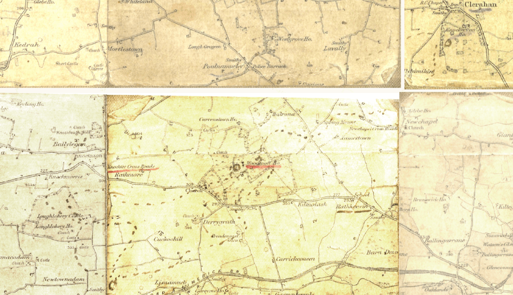
On the map Woodrooff House has been underlined in red ink and is surrounded by black ink track marks going in north, south and westerly directions towards Knockevan House and Knockfeagh Hill. Black ink circles are also found alongside these track marks near Woodrooff, Knockevan and Kilmaloge.
It is unsurprising that Woodrooff is marked so heavily on the map since it has been the site of many deadly attacks in the 20th century. During the War of Independence, three soldiers were executed near Woodrooff Church. Then during the Civil War, the Tipperary 3rd Brigade ambushed members of the National Army at Woodrooff, leading to the deaths of some and the wounding of many others.
The track marks run south from Woodrooff to Derrygrath, an area that Dan Breen says the column moved to at the time of the Woodrooff ambush. He also goes on to say that Derrygrath ‘was one of the column’s favourite spots for an ambush of the troops who were want to pass regularly along the main road between Clonmel and Cahir. The immediate position for a fight was excellent, being an elevated one over the south side [of the road]…‘. To read more of Dan Breen’s witness statment account of the IRA’s movements in the area, click here.
It is clear that the IRA were in the Woodrooff and the Derrygrath area where track marks can be found on the map. The question is, do you think the two are connected? Do the track marks show the movement of the IRA or the activities of others, e.g. the National Army? Do you think the markings are related to events that took place during the War of Independence, the Civil War or something else?
Whatever your thoughts are, we would like to hear them or any other information you may have about south Tipperary’s revolutionary period. To send on your thoughts or information, please email us at Landscapes@abartaheritage.ie.
The Tipperary Old IRA Map Project is funded as part of Tipperary County Council’s Decade of Centenaries Programme with support from the Department of Tourism, Culture, Arts, Gaeltacht, Sport and Media. This project is being delivered by Abarta Heritage as part of the Landscapes of Revolution Project.
