
The fascinating ‘Tipperary Old IRA Map’ is covered in intriguing ink and pencil markings. Today we are taking a closer look at some of the black ink markings which underline the names of villages, townlands and crossroads in the south of Co. Tipperary.
The black underlines are significantly fewer in number than the red underlines (connected with a variety of place names) and blue underlines (mainly linked to large houses). Of the two hundred plus markings on the map, only eight locations have been underlined in black. They include:
- Ballingarry
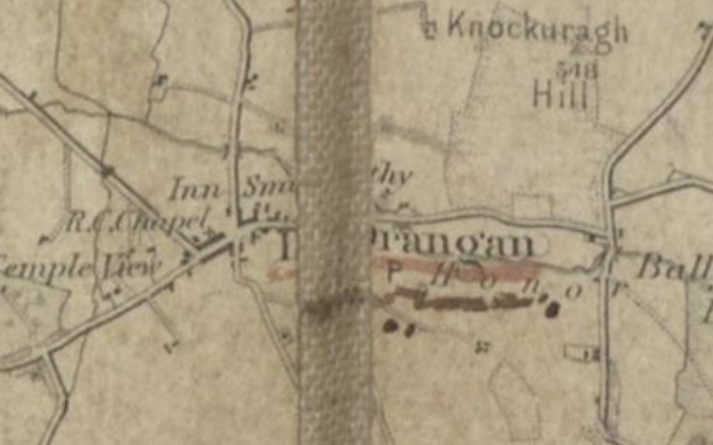
- Drangan
- Herrick’s Crossroads
- Moglass/Moyglass
- Mullinahone
- Rathkeevin
- Rathronan
- Thorny Bridge
It seems logical to think that all eight sites are connected since they are marked in the same way, but if you look closely at the map, you will see there are some differences. For example, the black lines under Drangan and Ballingarry are decorated with dots, see images below.
end of the line and two dots under the centre of the line

end of the line and two dots under the centre of the line
These unique markings are not found anywhere else on the map and seem to hint at a connection between Drangan and Ballingarry. Perhaps this connection might have something to do with the IRA attack on Drangan RIC Barracks and the destruction of Ballingarry RIC Barracks during the War of Independence? This would tie in with the faint pencil ‘RIC’ written on the map to the right of Ballingarry, which you can see in the image above.
Do you think there is a unique connection between all the black underlined places? Do you know of any link that Ballingarry, Drangan, Herrick’s Crossroads, Moglass/Moyglass, Mullinahone, Rathkeevin, Rathronan or Thorny Bridge may have to the IRA in the War of Independence or the Civil War? If you have any thoughts or theories on the black marks, we would love to hear from you.
If you would like to get in contact, please email us at landscapes@abartaheritage.ie or leave a comment at the bottom of this page. Alternatively you can share your information at our next public event which will be held in Cahir House Hotel at 7 pm on Thursday the 23rd of June. Keep an eye on our facebook page (@landscapesofrevolution) for more details of this event over the coming weeks.
The Tipperary Old IRA Map Project is funded as part of Tipperary County Council’s Decade of Centenaries Programme with support from the Department of Tourism, Culture, Arts, Gaeltacht, Sport and Media. This event is being delivered by Abarta Heritage as part of the Landscapes of Revolution Project.
