
Today we are taking a closer look at the fascinating ‘Tipperary IRA Map.’ Filled with intriguing markings that may be connected with Ireland’s 20th-century revolutionary period, we’re focusing on a section of the map around the town of Cahir (or Caher as it is written on the map). Markings such as blue underlines, red underlines and black…
Category: Uncategorized
Tipperary IRA Map Inception Talk, 8th of March 2022
On the 8th of March, we delivered an inception talk over zoom about the intriguing ‘Tipperary IRA Map’. This map which was in the possession of a local family for decades, has over two hundred markings on it which may relate to IRA activity in South Tipperary in the 20th century. As part of Tipperary…
New Release: Archaeological Maps of the 1920 Mallow Barracks Raid
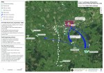
Our latest set of archaeological maps, examining the landscape of the important 1920 Mallow Barracks Raid, are the first in a series of four commissioned by Cork County Council. The work was undertaken by Abarta Heritage Ltd as part of Cork County Council’s Decade of Centenaries Programme supported by the Department of Tourism, Culture, Arts,…
Project Update
We recently completed our first workshop for those interested in volunteering to assist with the Landscapes of Revolution survey. On Saturday, December 17, 14 people joined us at the Midleton Public Library where we discussed a variety of topics from the project’s importance to the need for proper citation for locations. In addition, we discussed…
