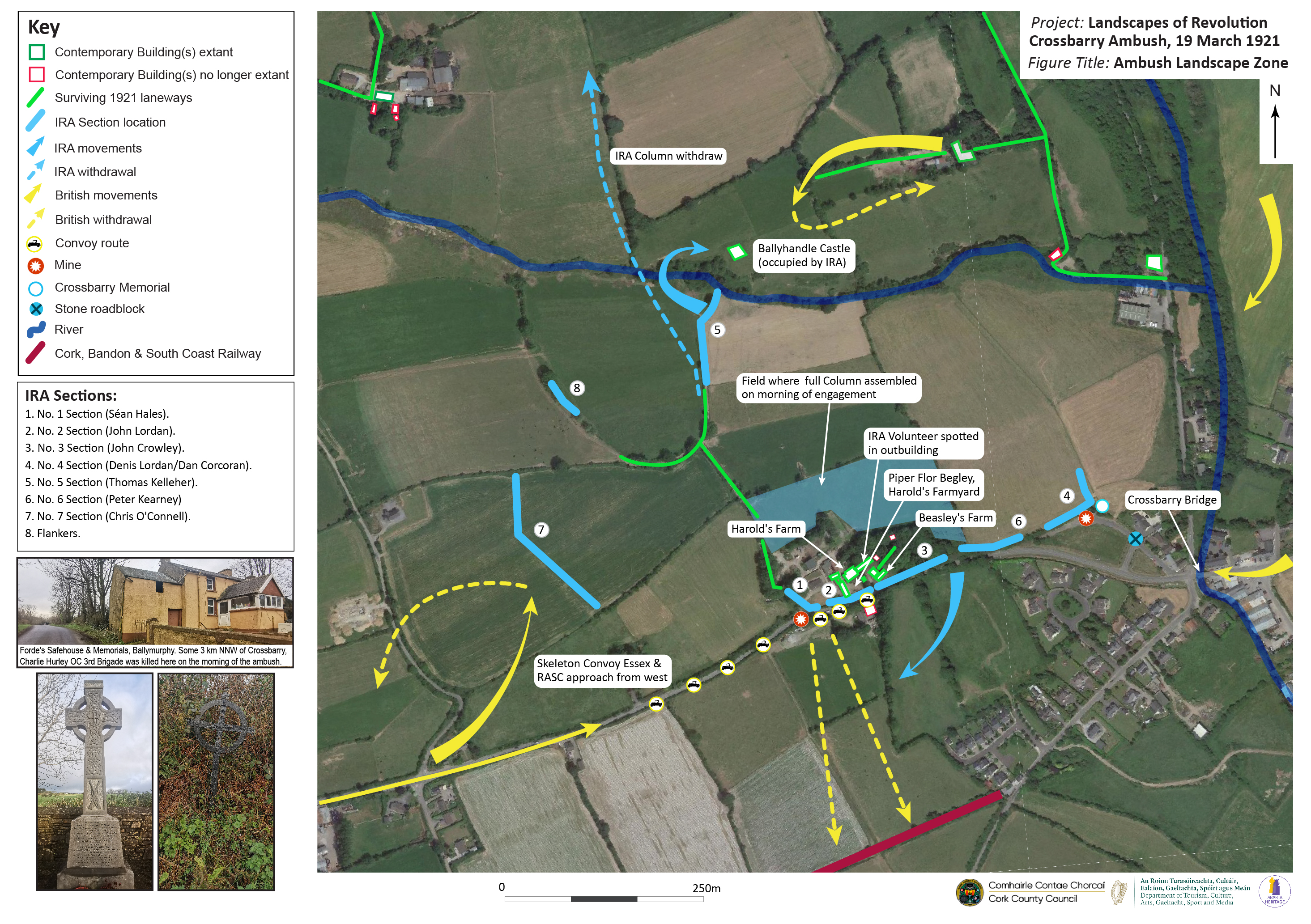
Our latest map is the fourth in the series commissioned by Cork County Council, and examines the archaeological landscape of the famed Crossbarry Ambush of 19 March 1921. Famous for the scale of IRA involvement, which ran to more than 100 Volunteers, the archaeological landscape of Crossbarry retains many of its 1921 features. Most notable among these are the Harold and Beasley farmsteads which formed the centre of the IRA position. It was here that piper Flor Begley famously played his pipes during the engagement, and where one of the IRA was spotted by the British lorries as they exited onto some outhouse steps, causing them to halt before they had fully entered the killing zone.
Although some of the field boundaries around the Crossbarry site have changed, many of the key boundaries utilised by the different IRA sections remain extant. Perhaps the most significant surviving feature in the landscape is the extensive laneway that runs north from the western-end of the primary ambush position. This laneway was a major feature of the engagement, and was one which the IRA made significant use of before, during and after the fighting. Many of the Volunteers exited the battlefield via this route. Further north, features such as Ballyhandle Castle and nearby houses were also the site of significant movement and action. Although not directly part of the ambush, our map also incorporates an image of the safehouse where Charlie Hurley, Officer Commanding 3rd Cork Brigade, was killed on the morning of Crossbarry. Located at Ballymurphy, a little more than 3km north-north-west of the main site of the engagement, the inset also incorporates the old and new memorials at the site that are dedicated to this key IRA leader.


Our Crossbarry map follows previous maps we have undertaken for this project that explore the 1920 Mallow Military Barracks Raid, the 1920 attack on Cloyne RIC Barracks and the 1921 attack on Rosscarbery RIC Barracks. The work was undertaken by Abarta Heritage Ltd as part of Cork County Council’s Decade of Centenaries Programme supported by the Department of Tourism, Culture, Arts, Gaeltacht, Sport and Media. As with our previous maps, it is intended to serve as a starting point for those interested in the exploration, examination and future management of the archaeological remnants of these important sites. You can explore the map in more detail my clicking on the image below. If you have any suggested additions or edits/corrections to the map, please contact the project via info@abartaheritage.ie.