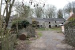
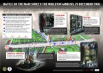
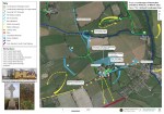
Tag: Landscapes of Revolution

New Release: Archaeological Map of the 1920 Cloyne RIC Barracks Attack

Our latest map is the third in the series commissioned by Cork County Council, and examines the archaeological landscape of the May 1920 attack on Cloyne RIC Barracks in East Cork. It follows previous maps we have undertaken for this project that explore the 1920 Mallow Military Barracks Raid and the 1921 attack on Rosscarbery…

New Release: Archaeological Map of the 1921 Rosscarbery RIC Barracks Attack

Our latest map, part of the series commissioned by Cork County Council, examines the archaeological landscape of the March 1921 attack on Rosscarbery RIC Barracks. The work was undertaken by Abarta Heritage Ltd as part of Cork County Council’s Decade of Centenaries Programme supported by the Department of Tourism, Culture, Arts, Gaeltacht, Sport and Media.…

New Release: Archaeological Maps of the 1920 Kilcommon Ambush

We are delighted to officially launch the archaeological maps that have been created as a result of the Kilcommon Ambush archaeology project. This work was undertaken by Abarta Heritage Ltd as part of Tipperary’s Decade of Centenaries Programme financed by the Department of Tourism, Culture, Arts, Gaeltacht, Sport and Media. The maps identify the major…

Kilcommon: Research Workshop & Memory Sharing Event

Tara Clarke of Abarta Heritage and the Landscapes of Revolution Project describes the Research Workshop and Memory Sharing event we recently held with the local community in Kilcommon, Co. Tipperary. One of the aims of the Landscapes of Revolution Project is to work with local communities to uncover their revolutionary past. Significant detail about events…

Press Release: Landscapes of Revolution Project Workshop & Memory Gathering Event

Thursday 2nd of September at 19.00, Kilcommon Community Centre, Kilcommon, Co. Tipperary Come along to the Landscapes of Revolution Workshop hosted by Abarta Heritage at Kilcommon Community Centre. All are welcome to attend this free event which will be held on Thursday the 2nd of September from 19.00 to 21.00. Drop in at any time…

Kilcommon Ambush: In Search of Safe Houses & Reprisals

A key element of the Landscapes of Revolution Project has been the identification and mapping of Safe Houses. These civilian homes and premises became increasingly important networks as 1920 progressed, and more and more volunteers were being forced “on the run.” Their central importance only accelerated following the formation of IRA Active Service Units (“Flying…

Press Release: Landscapes of Revolution Archaeology Project Exploring the Site of Tipperary’s Kilcommon Ambush

The Kilcommon Ambush of 16 December 1920 was one of the most significant carried out by the No. 1 (North) Tipperary IRA Brigade Flying Column during the War of Independence. Tipperary County Council have appointed the archaeologists of the Landscapes of Revolution Project from Abarta Heritage to work with local historians and the local community…

Interpreting the Archaeology & History of the War of Independence: The New Midleton Ambush Interpretive Panel

One of the main aims of the Landscapes of Revolution Project is to identify and raise awareness of the surviving landscapes of our revolutionary past, and offer communities new ways of conceptualising and interacting with the history and archaeology of the period. Over recent years, the project has invested considerable time in analysing the 1920…