
Join us on the 12th of May at our free Object Recording and Memory Sharing Evening in Halla na Féile, Cashel, Co. Tipperary (Eircode E25 WC59). The event will begin at 6 pm, and the evening will be spent sharing the latest research on the mysterious ‘Old IRA Map’ and hearing your thoughts, stories, and memories of…
A closer look at the Tipperary IRA Map
Today we are taking a closer look at the fascinating ‘Tipperary IRA Map.’ Filled with intriguing markings that may be connected with Ireland’s 20th-century revolutionary period, we’re focusing on a section of the map around the town of Cahir (or Caher as it is written on the map). Markings such as blue underlines, red underlines and black…
Tipperary IRA Map Inception Talk, 8th of March 2022
On the 8th of March, we delivered an inception talk over zoom about the intriguing ‘Tipperary IRA Map’. This map which was in the possession of a local family for decades, has over two hundred markings on it which may relate to IRA activity in South Tipperary in the 20th century. As part of Tipperary…
New Release: Archaeological Map of the 1921 Crossbarry Ambush
Our latest map is the fourth in the series commissioned by Cork County Council, and examines the archaeological landscape of the famed Crossbarry Ambush of 19 March 1921. Famous for the scale of IRA involvement, which ran to more than 100 Volunteers, the archaeological landscape of Crossbarry retains many of its 1921 features. Most notable…
New Release: Archaeological Map of the 1920 Cloyne RIC Barracks Attack

Our latest map is the third in the series commissioned by Cork County Council, and examines the archaeological landscape of the May 1920 attack on Cloyne RIC Barracks in East Cork. It follows previous maps we have undertaken for this project that explore the 1920 Mallow Military Barracks Raid and the 1921 attack on Rosscarbery…
New Release: Archaeological Map of the 1921 Rosscarbery RIC Barracks Attack

Our latest map, part of the series commissioned by Cork County Council, examines the archaeological landscape of the March 1921 attack on Rosscarbery RIC Barracks. The work was undertaken by Abarta Heritage Ltd as part of Cork County Council’s Decade of Centenaries Programme supported by the Department of Tourism, Culture, Arts, Gaeltacht, Sport and Media.…
New Release: Archaeological Maps of the 1920 Mallow Barracks Raid
Our latest set of archaeological maps, examining the landscape of the important 1920 Mallow Barracks Raid, are the first in a series of four commissioned by Cork County Council. The work was undertaken by Abarta Heritage Ltd as part of Cork County Council’s Decade of Centenaries Programme supported by the Department of Tourism, Culture, Arts,…
On the Trail of the Crossbarry Ambush Landscape
As is evident in all the projects undertaken as part of Landscapes of Revolution, one of our main aims is to highlight the significant archaeological traces that the War of Independence and Civil War have left behind. Ireland has traditionally viewed the majority of its early 20th century conflict landscapes almost entirely through the prism…
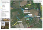
New Release: Archaeological Maps of the 1920 Kilcommon Ambush

We are delighted to officially launch the archaeological maps that have been created as a result of the Kilcommon Ambush archaeology project. This work was undertaken by Abarta Heritage Ltd as part of Tipperary’s Decade of Centenaries Programme financed by the Department of Tourism, Culture, Arts, Gaeltacht, Sport and Media. The maps identify the major…
Kilcommon: Research Workshop & Memory Sharing Event

Tara Clarke of Abarta Heritage and the Landscapes of Revolution Project describes the Research Workshop and Memory Sharing event we recently held with the local community in Kilcommon, Co. Tipperary. One of the aims of the Landscapes of Revolution Project is to work with local communities to uncover their revolutionary past. Significant detail about events…
Press Release: Landscapes of Revolution Project Workshop & Memory Gathering Event

Thursday 2nd of September at 19.00, Kilcommon Community Centre, Kilcommon, Co. Tipperary Come along to the Landscapes of Revolution Workshop hosted by Abarta Heritage at Kilcommon Community Centre. All are welcome to attend this free event which will be held on Thursday the 2nd of September from 19.00 to 21.00. Drop in at any time…
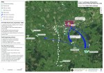
Kilcommon Ambush: In Search of Safe Houses & Reprisals
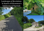
A key element of the Landscapes of Revolution Project has been the identification and mapping of Safe Houses. These civilian homes and premises became increasingly important networks as 1920 progressed, and more and more volunteers were being forced “on the run.” Their central importance only accelerated following the formation of IRA Active Service Units (“Flying…
